


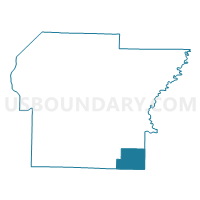
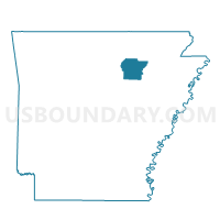
Departee Voting District, Independence County, Arkansas
About
Outline

Summary
| Unique Area Identifier | 526700 |
| Name | Departee Voting District |
| County | Independence County |
| State | Arkansas |
| Area (square miles) | 23.01 |
| Land Area (square miles) | 22.97 |
| Water Area (square miles) | 0.04 |
| % of Land Area | 99.81 |
| % of Water Area | 0.19 |
| Latitude of the Internal Point | 35.55605220 |
| Longtitude of the Internal Point | -91.42897740 |
Maps

Graphs
Select a template below for downloading or customizing gragh for Departee Voting District, Independence County, Arkansas


Neighbors
Neighoring Voting District (by Name) Neighboring Voting District on the Map
- Hill Voting District, Independence County, AR
- Macks Voting District, Jackson County, AR
- New Glaise Voting District, Jackson County, AR
- Oil Trough Voting District, Independence County, AR
- Olyphant Voting District, Jackson County, AR
Top 10 Neighboring County Subdivision (by Population) Neighboring County Subdivision on the Map
- Glaize township, Jackson County, AR (966)
- Oil Trough township, Independence County, AR (756)
- Hill township, Independence County, AR (357)
- Departee township, Independence County, AR (215)
- Bateman township, Jackson County, AR (52)
Top 10 Neighboring Unified School District (by Population) Neighboring Unified School District on the Map
- Newport School District, AR (11,706)
- Cedar Ridge School District, AR (5,465)
- Bradford School District, AR (3,010)
Top 10 Neighboring State Legislative District Lower Chamber (by Population) Neighboring State Legislative District Lower Chamber on the Map
- State House District 72, AR (28,138)
- State House District 58, AR (27,318)
- State House District 73, AR (26,277)